Wednesday, June 8, 2016

pigeon island national park


Pigeon Island National Park is one of the two marine national parks of Sri Lanka. The national park is situated 1 km off the coast of Nilaveli, a coastal town in Eastern Province, encompassing a total area of 471.429 hectares. The island's name derives from the rock pigeon which has colonized it.

 The national park contains some of the best remaining coral reefs of Sri Lanka.Pigeon Island was designated as a sanctuary in 1963. In 2003 it was redesignated as a national park. This national park is the 17th in Sri Lanka. The island was used as a shooting range during the colonial era.Pigeon Island is one of the several protected areas affected by the Indian Ocean tsunami in 2004.  

physical features


Pigeon Island consists of two islands; large pigeon island and small pigeon island. The large pigeon island is fringed by a coral reef, and is about 200 m long and 100 m wide. Its highest point is 44.8 m above mean sea level.The small pigeon island is surrounded by rocky islets. The national park is situated within the dry zone of Sri Lanka. The mean annual temperature is around 27.0 °C (80.6 °F). The annual rainfall ranges between 1,000–1,700 millimetres (39–67 in) while most of the rain is received during the North-eastern monsoon season from October to March.

flora and fauna

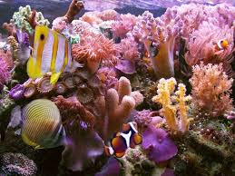
The large pigeon island's coral reef's vegetation is dominated by Acropora spp. with some Montipora spp.Faviidae, Mussidae and Poritidae species dominate the coral reef around the rocky islets. Areas with soft corals such as Sinularia, Lobophyton, and Sarcophyton can also be observed.

 The coral reef harbors many vertebrates and invertebrates. Many of the 100 species of corals and 300 coral reef fishes recorded around the Trincomalee area are found in the national park. Juvenile and adult blacktip reef shark are seen around the shallow coral areas. Hawksbill turtle, green turtle and olive ridley are the visiting sea turtles of the coral reef. The island is important breeding ground for the rock pigeon.
blacktip reef shark

green turtle


corals


Saturday, February 27, 2016

Piduruthalagala


Pidurutalagala , or Mount Pedro in English, is an ultra prominent peak, and the tallest mountain in sri Lanka, at 2,524 m .Mount Pedro is located close to the city of Nuwara Eliya, and is easily visible from most areas of the Central Province. It is situated North-North-East from the town of Nuwara Eliya.

Its summit is home to the central communications array of the Government of Sri Lanka and armed forces, and serves as an important point in the country's radar system. The peak is currently designated as an "Ultra-high security zone", and is protected by a large military base; being strictly off limits to the general public.

piduruthalagala


On 1 March 2010, a small wildfire broke out over the mountain's forest cover. The fire destroyed 3 acres (0.012 km2) of forest, before being doused by the Sri Lanka Air Force and nearly 300 local residents.

Hanthana Mountain range

The Hanthana Mountain Range lies in central Sri Lanka, south-west of the city of Kandy. It was declared as an environmental protection area in February 2010 under the National Environment Act.
The maximum height of the range is 3800 ft. The mountain range consists of seven peaks.

hanthana


The highest one being the Uura Kanda. The range is a favourite destination among the mountain hikers in Sri Lanka. University of Peradeniya is situated adjacent to the Hanthana mountain range.

Friday, February 26, 2016

Royal Botanical Gardens,Peradeniya

Royal Botanical Garden, Peradeniya is about 5.5 km to the west from the city of Kandy in the Central Province of Sri Lanka. It attracts 2 million visitors annually. It is near the Mahaweli River (the longest in Sri Lanka) It is renowned for its collection of orchids. The garden includes more than 4000 species of plants, including orchids, spices, medicinal plants and palm trees.

Attached to it is the National Herbarium of Sri Lanka. The total area of the botanical garden is 147 acres (0.59 km2), at 460 meters above sea level, and with a 200-day annual rainfall. It is managed by the Division of National Botanic Gardens of the Department of Agriculture.


history

The origins of the Botanic Gardens date as far back as 1371 when King Wickramabahu III ascended the throne and kept court at Peradeniya near the Mahaweli river. This was followed by King Kirti Sri and King Rajadhi Rajasinghe. A temple was built on this location by King Wimala Dharma, but it was destroyed by the British when they were given control over the Kingdom of Kandy.

Thereafter, the groundwork for a botanical garden was formed by Alexandar Moon in 1821. He used the garden for coffee and cinnamon plants.The Botanical Garden at Peradeniya was formally established in 1843 with plants brought from Kew Garden, Slave Island, Colombo, and the Kalutara Garden in Kalutara. The Royal Botanic Garden, Peradeniya was made more independent and expanded under George Gardner as superintendent in 1844. On his death in 1849 George Henry Kendrick Thwaites became superintendent. He served until 1879, when he was succeeded by Henry Trimen, who served until 1895.The garden came under the administration of the Department of Agriculture when it was established in 1912

There are avenues in the river drive such as Cook's Pine Avenue, Palmyra Palm Avenue, Double Coconut Avenue, Cabbage Avenue, and Royal Palm Avenue. The classical Avenue of Palms is in this Garden. One item with a significant history is the Cannonball Tree planted by King George V of the United Kingdom and Queen Mary in 1901. It is often laden with fruit, which are thought to resemble cannonballs.


During World War II, the Botanical Garden was used by Lord Louis Mountbatten, the supreme commander of the allied forces in the South Asia, as the headquarters of the South East Asia Command.


Images For Botanical Gardens Peradeniya


Thursday, February 25, 2016

dunhinda falls


Dunhinda Falls is a waterfall located about 5 km from Badulla town in Sri Lanka.The Dunhinda Falls is one of Sri Lanka's most beautiful waterfalls.The waterfall, which is 64 metres (210 ft) high gets its name from the smoky dew drops spray, (Dun in sinhala means mist or smoke) which surrounds the area at the foot of the waterfall. The water fall is created by the river called Badulu Oya which goes through the Badulla town


dunhinda falls


To reach the water fall you have to walk more than 1 km along a foot path. Along this foot path you can see another small waterfall called Kuda Dunhinda at a distance. However walking along this muddy foot path is really worth as the waterfall is so beautiful. Along this foot path there are many native venders selling herbal drinks to refresh and rest yourself. At the end of the path there is a secure stage constructed for viewers to see the waterfall. If you are brave enough you can reach the foot of the waterfall and cross the river and see the most beautiful view of the fall.

knuckles mountain range


The Knuckles Mountain Range lies in central Sri Lanka, in the Districts of Matale and Kandy. The range takes its name from a series of recumbent folds and peaks in the west of the massif which resemble the knuckles of clenched fist when viewed from certain locations in the Kandy District. Whilst this name was assigned by early British surveyors, the Sinhalese residents have traditionally referred to the area as Dumbara Kanduvetiya meaning mist-laden mountain range (Cooray, 1984).


knuckles conservotion forest

The entire area is characterised by is often robed in thick layers of cloud. In addition to its aesthetic value the range is of great scientific interest. It is a climatic microcosm of the rest of Sri Lanka as the conditions of all the climatic zones in the country are exhibited in the massif. At higher elevations there is a series of isolated cloud forests, harbouring a variety of flora and fauna, some of which cannot be found anywhere else in the world.Although the range constitutes approximately 0.03% of the island’s total area it is home to a significantly higher proportion of the country’s biodiversity

viharamahadevi park


The Viharamahadevi Park (formerly Victoria Park) is a public park located in Colombo, next to the National Museum in Sri Lanka. It is the oldest and largest park of the Port of Colombo. Situated in front of the colonial-era Town Hallbuilding, the park is named after Queen Viharamahadevi, the mother of King Dutugamunu. The park was built on land donated to the Colombo city by Charles Henry de Soysa during the British rule of Sri Lanka, and used to be named "Victoria Park" after Queen Victoria. During World War II it was occupied by the British Army with Australian 17th Brigade based at Victoria Park. After the war the park was restored and open to the public in 1951.
There used to be a cricket ground in the park, which was used for first-class cricket between 1927 and 1995. Ceylon played against a touring English team there in 1927 and against an Australian team in 1935.
The park features include a huge Buddha statue and a series of water fountains. It also includes a mini zoo, a children's play area and a BAC Jet Provost.

buddha statue

The Viharamahadevi Park is the only large-scale public park in Colombo, and is maintained by the Colombo Municipal Council. Located at its western end is the Cenotaph War Memorial, Colombo and the Colombo Public Library. The Vihara Maha Devi Park Open Air Stadium is a venue for concerts and public events.